Nahuel Huapi traverse
Nahuel Huapi Traverse is an outstanding hike route with fascinating views and beautiful lakes on the way. It is also the most demanding hiking route we have ever done. Unforgettable views and experience makes it a highlight of our trip to Argentina. In this post I gather some basic information about the route and my personal notes in hopes it will help a future traveller or entertain a landscape lover.

At a glance
Level: very hard (scrambling, exposure, route finding)
Time: 4–5 days, December to April
Weather: strong winds
Sleeping: dormitory beds in refugios (around 1000 ARS / £14) or free campsites near refugios
Eating: bring your own food or buy meals at refugios (around 1900 ARS / £24 full board).
Water: no need for purifying tablets or filter, bring extra bottles or camelback
Map: offline map of Argentina in maps.me has the path marked
Guidebook: Lonely Planet «Trekking in the Patagonian Andes» 2009


Schedule
During first two days of hiking we’ve learned that difficulty of the route is serious, and, knowing that day 3 is the hardest and most dangerous part, we decided to skip it because of our heavy 15 kilos backpacks. Instead, we went down to the road and hitchhiked to Colonia Suiza one day and ascended to refugio Segre the next day. Both descent and ascent are longer, but they are very easy comparing to constant scrambling and bouldering of the route itself. So if you are concerned with day 3 difficulty, or simply are unfortunate with the weather, you can follow our schedule.

Map of our hike from Bariloche Trekking. The red lines are high walks, the yellow lines are easy descents/ascents, and the blue is hitchhiking part. The gap of day 3 in traverse route is clearly visible.
Day 1: Villa Cathedral to Refugio Frey
Time: 2¾ – 4 hours, 8.5km
Our time: 6 hours
Transport: bus 55 from Bariloche to Villa Catedral (pay with Sube card and make sure there is enough amount left for the way back), cable car Telecabina Amancay (1050 ARS / £15), then Diente de Caballo chairlift to the top (it didn’t work when we arrived, so we hiked up in 40-50 minutes)
Sleeping: Refugio Frey is popular with climbers, so it is important to have a booking when you come — yes, camping needs to be booked, too!
Day 2: Refugio Frey to Refugio San Martín (Jakob)
Time: 5 – 6 ½ hours, 8.5km
Our time: 8 hours
Sleeping: Refugio Jakob is my favourite, with good food and bright staff. There’s no need to book a camping spot anywhere except Frey.
Day 3: Refugio Jakob to Colonia Suiza
Time: 5–7 hours, 18 km + 7 km hitchhiking to Colonia Suiza
Our time: around 8 hours in total, we took it easy :) Though the road looked empty, hitchhiking was extremely easy, because locals are friendly and happy to help.
Sleeping: we stayed in a lovely camping Ser (400 ARS per person per night) with their hot showers, warm friendly atmosphere, and huge kitchen. There is a couple of other campings around.
There are lots of cosy cafes and lively bars around.
Day 4: Colonia Suiza to Laguna Negra
Time: 5-6 hours, 14km
Our time: 5 hours
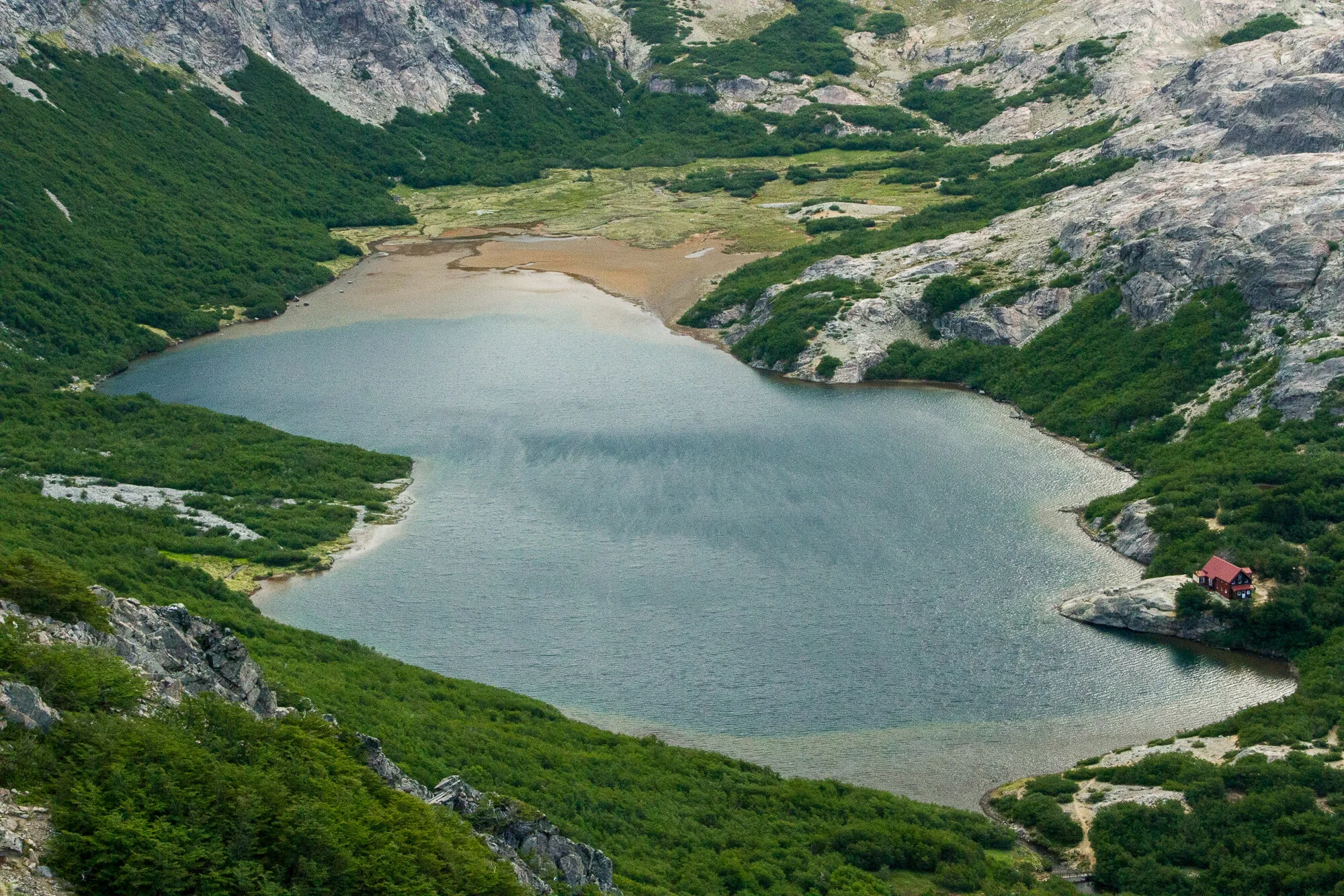
Sleeping: Refugio Laguna Negra aka Italia is famous for its candlelit dinners and rustic atmosphere. Camping is a bit too far from the refugio and its toilet.
Refugio Italia (Laguna Negra) prices
Day 5: Laguna Negra to the end of route
Time: 5½ – 8 hours, 11 km
Our time: it took us around 9 hours, but it felt like eternity.
Staff in refugio Italia has photos of the route and can explain directions.
Download gpx track Laguna Negra – López and López – end of trail
Sleeping: the route goes past refugio López. However, it is located quite close to the end of trail: 1½–2 hours of steep dusty descent to the bus stop. So we stopped there for a cup of tea (they didn’t have any food except snacks) and continued our hike.
Transport: At the end of the route, when facing the road, with a kiosk on your left side, turn right and walk around 300 m to the T-intersection. It is the bus stop. There is no sign, but most likely you will see a crowd of people waiting for the bus.
Tips
Before trekking, please register online or in the tourist office in Bariloche.
Drop unnecessary items in Bariloche.
Check the weather before heading out.
Don’t do day 3 in anything but perfect weather conditions.
Trek Bariloche, Bariloche Trekking, Best Hike websites have a precise description of the classic 5-day route as well as the side treks.

View at Nahuel Huapi lake during the final descent from refugio López

A small side trip from refugio Jakob to Laguna de los Témpanos
In details
Level
I know we are all made different, so it is hard to judge the level of any route from reading a blog post by a person you don’t know. That said, I promise you, this trek will be hard. Brace yourself.
It is an exhausting route, and includes lots of scrambling, some exposure, hours long arduous descends through steep scree and unstable shaky rocks. We were preparing for our first marathon run before heading off to Argentina, so I would say we were quite fit when we started the trek. Though neither of us lived in mountains, we did a few long distance hikes, including in Alps and Himalayas, so we thought we’ve got enough experience to do Nahuel Huapi Traverse. Still, we were not expecting it to be that difficult. We were moving with speed of 1 km/hour most of the time.
Obviously, the difficulty depends not only on your fitness level, but also on the weight of your backpack. And our backpacks were around 15 kg each, because we carried out own camping equipment and food, not only for this trek, but also for the next one. Looking back, I’d say we could improve our weight by a couple of kilos by leaving in Bariloche all the stuff we didn’t need for this trek. In addition, one can go completely lightweight by staying and eating in refugios.
Anyway, the route was worth all the effort. The views were among the best I’ve ever seen in my life, and there were some rewarding moments during the trek where we could relax and enjoy ourselves.

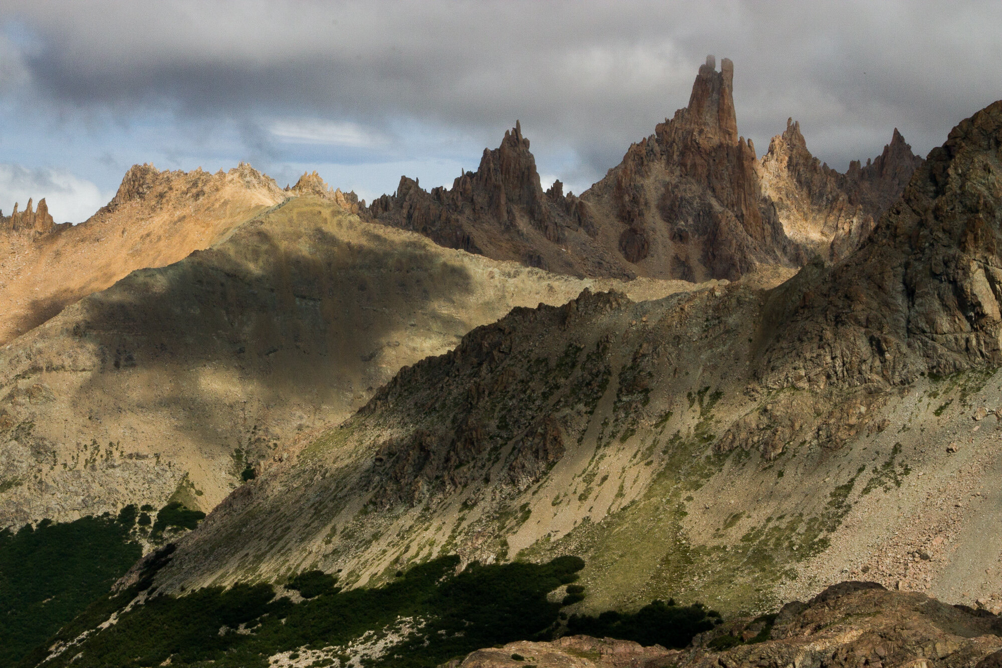
Does it look like a usual hiking path to you?

A couple of hours scrambling and you still see the starting point. The route is visible in the bottom right corner.

See the tiny speckles in the middle of the picture? Those are people navigating the loose stones near refugio López.
Time
Nahuel Huapi Traverse takes 4-5 days in total, and its beauty is in its flexibility. There is an easy link between any refugio and the road to Bariloche, so backpackers with less amount of time can choose to do only a part of the route (in fact, there are one- or two-day hikes to the refugios); less skilled or unlucky in terms of weather trekkers can skip the most demanding day 3, as we did; and people who are not keen at hiking can just use the easy ascent to camp near refugio for a couple of days and enjoy the views around.
We planned five days for hiking, so after we’ve spent two days instead of one getting to Laguna Negra, we had to combine day 4 and 5. Day 5 is just a couple of hours of steep descent by a dusty path in a forest — not much, but after the whole day of fighting with the terrain and rocky boulders, it is tiring. After the descent you have to ride fully packed with hikers and their backpacks bus to Bariloche, so prepare for the long day if you don’t want to stay in López.

It doesn’t matter which way one comes here, there is enough beauty for every type of traveller.
Weather
The best time to do Nahuel Huapi Traverse is in summer, December to February in southern hemisphere, though some people say that fall time in April is more beautiful and less crowded. We did it in January and were very lucky with the weather. It wasn’t much wind and there was only one overcast day with a bit of rain.
The good weather is vital for this route. It is usually quite windy in mountains, but here gusts of wind can throw a person down from the cliff, and rain makes every step more dangerous than it already is. Check the weather forecast when you are still in Bariloche, because there will be no coverage on the route. The tourist office in Bariloche used windy.com, and it turned out to be a reliable forecast even for a few days in advance. Some refugios have an updated forecast, some just look at the sky and tell you what is already obvious. If weather is anything from perfect, don’t do the day 3.
Even in summer period don’t leave back the warm clothes, especially if you are camping. It is not very cold during the day, but it is hard to enjoy a sunset if you can’t move your frozen fingers. I had 5 top layers: base, fleece jacket, dawn vest, dawn jacket, waterproof jacket — I haven’t used only dawn vest on this hike. As for the bottom layers, I used all three of them: warm base layer, trekking pants, and waterproof, but never all at the same time, so if you don’t have the base bottom layer, don’t despair, it will be fine. Campers will find useful a pair of fleece gloves.

There might be an occasional patch of snow to walk through, but mostly you will see it covering the steep rocks all around. The route from refugio Jakob to Laguna Negra, though, may require crampons — ask the staff at Jakob about the weather conditions.

And don’t forget a hat and sunscreen!
Sleeping
Backpackers can stay only in refugios or designated campsites on the route. Refugios are crowded and may seem expensive, but they are a good way to hike lightweight. Campsites, which are located near each refugio, are free to use, more or less sheltered from the wind, and have nice views.
It is necessary to book camping in refugio Frey (first night), because it is always full with climbers who practice their skills on the mountain nearby. There are only slots for the next three days available, and they go fast, so wake up early 3 days before you plan the trekking, and book your place. Sometimes people cancel the booking, so if you missed it, don’t despair, and check now and then for a slot available. The other campsites have enough space and don’t need to be booked.
Using refugios is a good way to leave a few kilos of camping equipment out of your backpack. Our backpacks were too heavy to enjoy the route. Next time we will probably leave all our stuff in Bariloche and do the whole thing lightweight — and I’m sure there will definitely be the next time :)
Sleeping in the tent makes the whole experience more enjoyable, if not fresh. To improve your sleep and make sure you’ll make only good memories, pick the tent that can withstand Patagonian winds and occasional gusts up to 120 km/h. We’ve just bought a new Hilleberg before this trip, and it did an excellent job of not moving an inch. But we’ve heard unpleasant stories about broken tents, so choose wisely.

Refugio Frey staff resting after breakfast
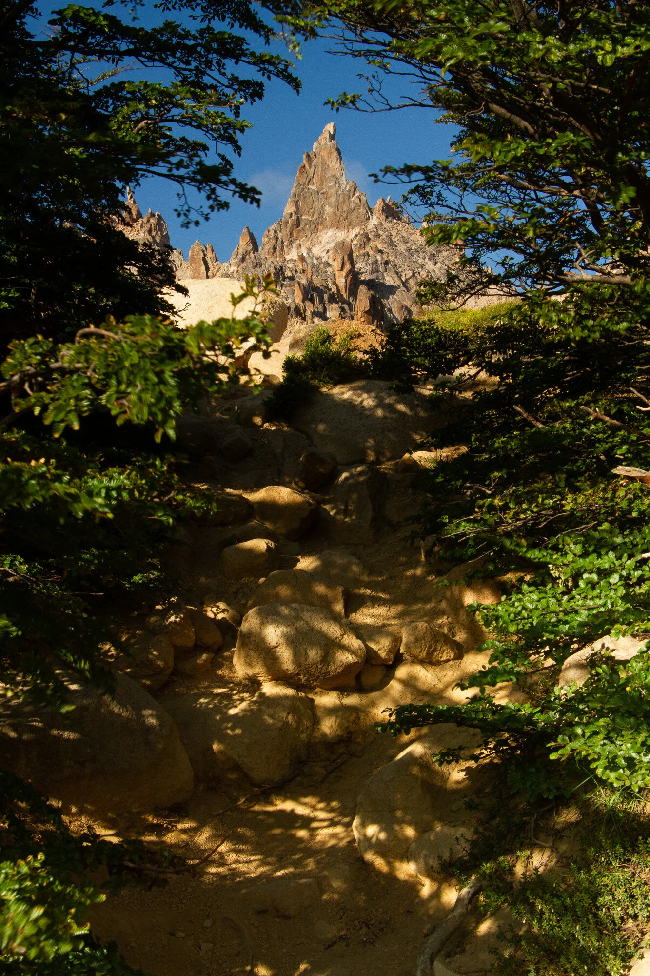
Path from camping to refugio Frey
Refugio Jakob seen from the top
Food
Here, too, hikers have plenty of choice and combinations. You can buy in refugio anything from snack or sandwich to full-board — provision of full three meals: dinner, breakfast, and packed lunch. Otherwise, you can bring your own food, cook it on your stove, or in refugio kitchen (for around 300 ARS). Usually we cooked our own food and bought sandwiches for lunch in refugios before heading out. But again, that meant carrying all the food for five days. So it may be wiser to eat at the refugios, or at least bring the food for the first two days and eat most of it before day 3 if you plan to stick to traverse route. Keep in mind that refugios have set time for the dinner (usually at 7-8 pm), so hurry up if you rely on that.
There is no freeze-dried food in Argentine outdoor shops, so if you are spoiled like us, bring your own. There are supermarkets in Bariloche where you can buy usual food like macaroni and cheese, or whatever you prefer. La Anónima supermarkets are my favourite to shop in.

One of our favourite frozen food brands is Adventure food.
Water
All water in refugios is safe to drink. We also drunk water from lakes and rivers without purifying it. But there are long stretches without any water at all, especially during days 3 and 4, so check the map and fill your bottles before heading out of refugio.

Laguna Schmoll is a nice spot for a picnic.

Don’t drink standing water, it is not good for you.

Side hikes through forest to and from Colonia Suiza were quite entertaining and provided vital refreshment after the hard route.


Volcano Tronador is visible on the fourth day of hiking. The border between Argentina and Chile goes through its top.

The view from our camping spot near refugio Frey


MOUNTAINS

LANDSCAPES

URBANSCAPES